I’m not sure how something like this could happen. Don’t pilots have to know where they are before they land a plane? What? No GPS on this plane? Can someone with airline pilot experience answer this question?
Goddamn Apple Maps. I thought they’d sorted this thing out!
No airline experience, but I am a pilot who flies in a combined military/civilian airspace so until we get an ATP certificate in here, I AM TEH EXPURT!
So, short answer is, there is no excuse for this. Nevertheless, it happens. The reason is 100% pilot error, complacency, inattentiveness, poor cockpit management, and/or some combination. Of course there is GPS, and a host of other navigation tools available. But during clear weather, airline pilots fly exactly the same type of “pattern” into landing as us Cessna pilots. They go a bit faster, and they may have some computerized assistance for portions, but otherwise they fly the airplane onto the ground just like I do.
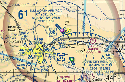
And but so, here is a picture of the airspace around Rapid City & Ellsworth:

Lots of Double-Secret Pilot Stuff on there, but the little blue line with the pink/white dot is the runway of Ellsworth, and below it the blue line with the green/white dot is Rapid City. Note how the runways are in rough alignment - that’s key to understanding how this could possibly happen. Also note that Ellsworth’s runway is bigger - the little graphic isn’t to scale, but reading the Secret Pilot Stuff I know that Ellsworth’s runway is about 13,500 feet long, and Rapid City’s is about 8,700 feet.
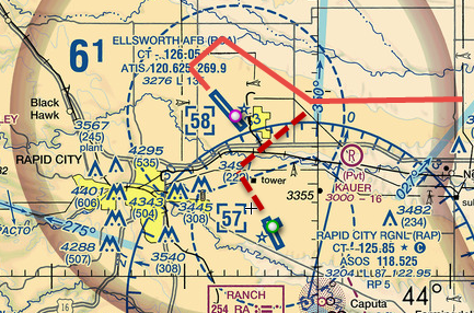
According to the weather history for Rapid City, yesterday at 8PM wind was out of the South, maybe 5 knots. They likely were using runway 14 at Rapid City, meaning the plane would be heading SSE when landing (into the winds which were coming from the South). That means the plane would be approaching the airport on the north side; that is, they would likely be flying almost directly at Ellsworth (they were coming from Minnesota, so flying west).
So their flight path could have been the bright red line, and they intended to take the dotted dark red path, but when the noticed this big huge runway in front of them they were all, “Hey, I can see the runway” (they actually tell ATC this) and from there they do their left-turning pattern and land (solid red line). Add in the fact that it was near sunset and the pilots may not even have noticed that other airport just to the left. Big-ass runway, let’s go there!

So, things that should have clued the pilots in that they were landing at the wrong place:
-
Runway has a big number on it - Ellsworth’s runway is 13 (stands for 130 degrees magnetic, by the way - the rough direction of the strip). ATC told them, “Cleared for the visual approach to runway one-four” and the pilots completely ignored the big 13 on the runway.
-
Runway was nearly a mile longer than Rapid City’s. Pilots may have been unfamiliar with the area, and just didn’t have the expected runway length at the top of their minds. Flight Management System says the destination runway is plenty long enough, they don’t need to concern themselves with exact numbers.
-
There is no crossing runway at Ellsworth, but Rapid City has a small 3,600 foot runway that crosses the main one. Again, unfamiliar with the area.
-
A few extra B-1 bombers in the parking area than expected. Possibly by the time they realized that Southwest had - apparently - upgraded its fleet to B-1s, they were committed to land.
You might ask, “why didn’t ATC tell them they were going to the wrong airport?” Well, it’s a bit Secret Pilot Stuff, but a “Class D” airport like Rapid City likely doesn’t have its own radar. So if you say “I can see the runway” and they say “cleared for a visual landing” you’re kind of on your own. The tower has binoculars and whatnot to see you if they want, but they don’t track every plane visually right to the ground.
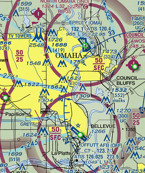
Here’s one of the areas I fly in frequently:

Omaha’s civil airport on top, Offutt AFB below. This is “Class C” airspace, so radar coverage is more intense. I’m not sure if anybody has landed at Offutt accidentally, but a 727 landed at the (tiny) Council Bluffs airport in 1969. Had to completely empty the plane to get it light enough to take off again.
A good list of similar incidents: http://www.thirdamendment.com/WrongWay.pdf
Pro tip: never ask a pilot to talk about flying, unless you have plenty of time to listen (or read). 
The aircraft shown in the photo accompanying this story is not an Airbus A320, it’s an Embrarer ERJ-175, and despite the livery, it’s not operated by Delta Airlines, it belongs to Compass Airlines, which operates as Delta Connection. You can do better. It took all of three minutes to find this photograph of the actual airplane: http://www.planepictures.net/netshow.php?id=1104593.
Great explanation.
Burning questions:
Did Delta lose anyone’s luggage?
Does Ellsworth have a Starbucks on base?
Thanks. Very enlightening.
Another pro tip:
Don’t ask a question unless you want to risk learning something.
Thank you, Obi Wing!
it really can be a fuckup if the wrong runway is shorter than the plane needs.
Thank you for your brilliant and illustriative response, expert pilot, complete with all those visuals!
Thanks very much, boidster ! And yes, I did want to learn all those things.
I bet pilot and co-pilot will be reporting to re-training and suspended from flying commercial with that airline for a couple of months until they decide to pay more attention before takeoff.
Some years back that happened in Augusta, GA. They had to strip the commercial airliner of every ounce of weight that wasn’t absolutely needed to fly the beast, and then bring in a test pilot to get it into the air. Locals loved to talk about it. I’m pretty sure it was another case of runways with the same headings at two nearby airports.


